|
Home | Submit info | Read Comments | Evacuee Offers | Donate | About Us |
|
If you are viewing this page you have an old bookmark or
link.
Please Click here for the new Page.
|
Home | Submit info | Read Comments | Evacuee Offers | Donate | About Us |
|
If you are viewing this page you have an old bookmark or
link.
Please Click here for the new Page.
|
|
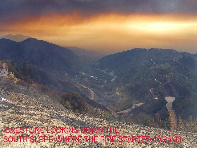
Fire origin was on Old Waterman Road & Hwy 18
|
| Lafonzo Rachal Carter / San Bernardino Sun |
 |
|
||||||||||||||||||||||||||||||||||||||||||||||||||||||||||||||||||||||||||||||||||||||||||||||||||||||||||||||||||||||||||||||||||||||||||||||||||||||||||||||||||||
| Link to an interesting article | |||||||||||||||||||||||||||||||||||||||||||||||||||||||||||||||||||||||||||||||||||||||||||||||||||||||||||||||||||||||||||||||||||||||||||||||||||||||||||||||||||||
|
This is Old Information, You are using an old Link. For new information, Click Here.
Mountain Residents can pick up
their mail at 195 Del Rosa in San Bernardino! 8:00 pm Friday - I'm answering emails as fast as I can, please be patient. 7:00 pm Friday - Fires in Running Springs are looking positive. Not out but being held back. Super Foggy. Edison is fine with letting people back into Crestline area in 4 days. But they are not the final authority. Drove up from Twin Peaks to Rim forest along Bear Springs Road. Everything looked good along the road. Report on the Cedar Glen Area. Wow, what a job. I'll try to have more later. Very Dangerous. Heavy Ash falling. Trees down. Findings below.
5:20 pm Friday - Ranger Al is in Cedar Glen Right now. I'm talking to him on the phone. I will have an update on homes in a few minutes. I must apologize about the emails folks. I haven't got many out since we've been working on the burned homes update. I am really backed up. 423 emails waiting to be answered. I'm supposed to take my kids Trick or Treating in an hour. Things are not looking good for that. I have a house I can go to if I choose. The thought of the 90,000 who don't have that ability will keep me working. I will stay here and continue updating. If anyone sees a 5 year old Pink Witch, a 7 year old Ninja Vampire and a 2 year old Ghost knock on their door, tell them that their dad say's hi and he loves them. Stay out of the Big Bear Area. The fire is close but is being kept back by the weather. Please Evacuate. Email notice- I would like to ask everyone to please only email me if you have a real important question or comment. I'm not able to give information about Big Bear or Running Springs or Status of burn areas if I am busy answering the same questions over and over. I don't mean to say that anyone is not important but at this point I must prioritize. I am going to list not vital questions with their answers here.
4:27 pm Friday - Here is a report on the Arrowhead Villas / Crest Park Area Arrowhead Villas. We traveled down Arrowhead Villa Rd, Around all the side streets and up and down Kuffel Canyon. No homes burned. Crest Park Area- South of 18 West of 173 Near the Park/Campground GPS 34° 13.74 N 117° 12.12 W
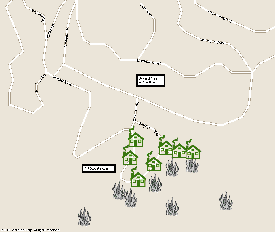
3:55 pm Friday- Trick or Treating in Redlands. Starting at 5pm tonight at the LDS Church on Pioneer Street in Redlands for evacuees. 3:27 pm Friday- Crestline Village Water Company reports no damage to any of their system. 2:15 pm Friday- Skyland area in Crestline update- Homes burnt. Sorry it took so long to get this info to you. It might be hard to read. It's a mess up there. Trees are down everywhere so we couldn't drive in but here is what we could get. GPS of burn area- 34° 13.91 N, 117°16.99 W, 34° 18.83 N, 117°17.02 W, 34° 13.86 N, 117°17.10 W
More info coming from Rockview Area. Stay watching if this is your area. more houses coming in.
2:00 pm Friday- CNN reports that it might be Saturday November 8 before residents are allowed to return. I have no confirmation on dates yet. I'm hoping its sooner. Over 90,000 people away from their homes. My friends and family are among you. Try to keep spirits up. I am trying too. The worst part is the not knowing whether you have a home to go home to. Many of you have found this site useful for detailed information but for the most part, people have to rely on TV news. Let's do two things. Let's let the Media know what we need to hear or lets get them to tell people about this site. As long as people get the info. Cedar Glen- We have been trying to figure out how to best help those in Cedar Glen. Address Checking is next to impossible in that area because we can't see street names or addresses due to the fire. So this is the plan. Ranger Al is armed now with a GPS device. He is going to give us the GPS coordinates around the burn area along with address's of all the homes in the burn area that are still standing. Hopefully this will be the best way to accurately display the destroyed homes. Running Springs- Firemen are actively defending RS. School is fine. Wow, this is getting to be a real long page. hmmm. I think it needs a reorganization. I think I should combine all my address that burned into one area as well. Hmmmm. Decisions decisions, answer more emails or reorganize. 1:45 pm Friday - If you are here for the first time please read this column before you email me. I just got another 150 or so emails. I am answering as fast as I can. I'm backed up with over 300 now. I'm just one guy answering these. Don't hate me if it takes me hours and hours to get back to you. Please read this information first!!! I just heard there are people contacting the Tonight Show to try to get Ranger Al on as a guest. LOL. 1:00 pm Friday - Reports that fires near Hesperia are controlled. There are a few small towers of smoke coming from the back side of the mountain but nothing big. 12:55 pm Friday - The Church of Jesus Christ of Latter-Day Saints has local "Trunk" or Treats set up at their local buildings for all those evacuees that would like to take their kids trick or treating. They are also organizing such events in the high desert and San Diego areas. I will post information on these as I get them. 12:30 pm Friday - A lot of emails want to know about Blue Jay. Blue Jay is safe. Rumors that Jenson's and the Ice Castle burned down are totally false. North Shore area and Golf Course area is ok too. 12:15 pm Friday - No worries about gas. Ranger Al has 100 more gallons. Thank you for all those who were willing to donate. Cliffhanger update - Ocean View Drive- The addresses listed are standing but 2 houses east of 25008 have burnt as well as the house across the street from 25008. Also the house across the street from 24988. 1 house east of 24929 burnt. The house on the west end of Ocean View and Crest Forest Drive is burnt. (Corvette burned in the driveway) I must repeat the addresses listed 25008, 24988 and 24929 are still standing as well as any home that doesn't fit the descriptions I've listed. I wish I could be more specific but even digging through the rubble, Specific address can not be found. 12:03 pm Friday - A lot of people are trying to get up the back side of the mountain. Traffic is thick up the Cajon pass. The roads are all blocked off and they are turning you away. Just wanted to save you a trip if you were thinking of trying it. Ranger Al says seeing trees that are Black on bottom and White on top from frost is really unique. We will try to get pictures soon. Back fires and fire breaks are actively being made in Running Springs. Big Bear- Its getting close. 11:11 am Friday- I have a thing with my wife to think of her every time I see the time as 11:11. Took a quick second to call her. Now I'm back to the emails. 250 of them. Please be patient. Ranger Al is actively viewing homes in the cliffhanger area. I will report as soon as I hear from him. He then will head to Arrowhead Villas and down into the burn zone. 10:45 am Friday Morning - TWIN PEAKS NEWS - I know everyone's been wanting to know. This is the scoop. Do NOT get worried and read this whole paragraph. A home at 25706 Hwy 189 in Twin Peaks has burned. BUT......... It looks like a whole separate fire. There is not any other homes or even forest burned near it. The rest of Twin Peaks looks fine. 10:20 am Friday Morning - My inbox is backing up to 200 right now. I am typing as fast as I can. I'm trying to keep the website updated as I do this. Please keep your email to a minimum. It is taking me a long time to read the emails that are 3-4 paragraphs long. Also be as specific about property as possible. I do know a lot about the area but just telling me a street name is hard to understand. Each town up in the mountains can have that same street. I'm really sorry if it takes me a long time to reply. I am only 1 guy. :) Speaking of which, you may want to listen to KFI am 640 at noon. You might recognize the guest. 10:10 am Friday Morning -I received information for any members of the Church of Jesus Christ of Ladder-Day Saints that are evacuated from the mountain area. Services will be held at the Northpark Building in San Bernardino at 1pm on Sunday. Any other organizations that have similar information can contact me at admin@fireupdate.com. 9:37 am Friday Morning - The fires are being beaten by firefighters in Running Springs. I believe the structures including the Cedu schools are safe. More info about CPP- Just got back from a visit there. 743 sandhill and the home across the street (couldn't find address) have burned down. This is not a recent fire but we were unable to confirm this in our visit yesterday. 9:25 am Friday Morning - I've been asked a lot about the status of other towns. Arrowbear, Green Valley Lake, Angelus Oaks and others. For now these areas are safe and I haven't heard about any burning. I will continue to update. I just answered 30 emails but got 80 more. :) Fun Fun. North Shore- If your home is on the North Shore of Lake Arrowhead please do not email me. Homes on that side of the lake are safe. All dangerous fires are away from CPP, VOE, Crestline, TP, RF, Blue Jay, Lake Arrowhead & Cedar Glen. Running Springs- Fires are very close to being under control here. If the weather keeps up, we will win this one. Down the Mountain- Areas like Yucaipa at the base of the mountain are justifiably being warned but I don't believe there is any imminent danger. 8:30 am Friday Morning - A big thank you to those who started to call me at 5am. It'll make me think twice about ever publishing my cell phone again. I guess I'll sleep sometime next week. 139 emails waiting for me when I arrived here at the office, 8 of which included viruses. :) I have to count my blessings, I still have a house. K, on to bigger things. Running Springs Front- Firemen have kept the fires down overnight. The weather being a huge help yet still an obstacle to the firemen. I'm sure you all know what I'm talking about. If you've lived on the mountain for even a small amount of time, traveling around the mountain in the fog can be challenging especially for people who don't know the mountain very well. There are still some hot spots around RS but the big uncontrollable "Wall of Flame" is no where to be seen. Big Bear- Fire is only about 5 miles west of Big Bear right now. Let's hope the weather can slow it down long enough let us prepare. Good news, we may be up for one of our first big snow storms of the season! Wow, what timing for these people in Big Bear. Hesperia- From what I've heard there are still some fires around the area. I will find out more and let you know. On to my morning research. 3:00 am Friday Morning- I remade all the maps down below with updated information. My email box is empty. I'm going to bed. I'll try to be up as soon as possible in the morning. Ranger Al is starting his day at 5:30am. So I'll have some good info to report when I wake up and noon. :) ok, I'll get up early. See you tomorrow. 1:15 am Friday Morning- Weather conditions- Wind is blowing SW at 20 MPH. 60 degrees, humidity 50. The following map is from 5:00 pm today. Thanks to the Forest Service for the info.
1:00 am Friday Morning- Just checked the stats for today. 459,985 Hits, 48,113 Page Views. Wow! It looks like people really do look at this site. I thought for a while everyone just emailed me. Glad to see it. No wonder the site ran so slow this morning. Big Bear Lake- Fire looks like it is coming. Ranger Al need to spend most of his time in the lower communities. If you know anyone that is still in Big Bear, please have them contact me so I can offer the same detailed information there as I'm trying to do for the other areas. 12:30 Early Friday Morning- Just finished my emails. Whhheeewww. 506 replies today. Hopefully I'm done for the night, so I can focus on updating the site. 10:00pm Thursday -I've heard that the gas station in Rim Forest will be open with generators Tomorrow from about 5-6 different sources. If this is true it will be a blessing for Ranger Al. Thank you to all those who emailed me about donating some gasoline. I've replied to about 394 of your emails so far since 10 this morning. I still have about 85 in my inbox. I am going to take a quick break from that for a while and call my wife and kids. I'll be updating some maps and pictures on the site soon. Thank you for your great comments, that is what I am running on now. 9:00pm Thursday - Fire is in the forest heading toward Lucerne Valley as well as around parts of Running Springs. If the weather stays cool and foggy, we may be able to stop it before it grows wild again. Good news. Supposed to rain tomorrow. 7:30pm Thursday - I just heard on the radio that no homes were lost in Cedar Pines Park. It was even one of the biggest stations in Southern California. This is absolutely untrue. The home listed below did burn down. Ranger Al gathered the addresses 1st hand. 6:20pm Thursday - Fire is being fought at the bottom of Running Springs School Rd near Seymour Rd.
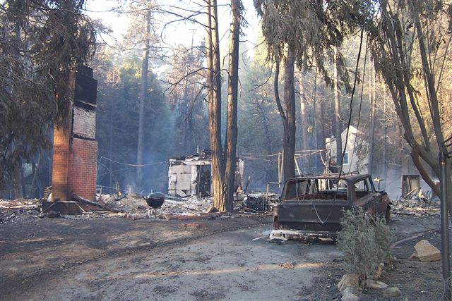
I cannot give you information on specific residences in the Cedar Glen Burn Zone. There are so many homes burnt that wasn't able to tell what address was what. Please read below for the information on the houses I did find still standing. Do not email me and ask about other houses in this area. If your house is North of the Dam you should be safe. If your house is off of hook creek before Deep creek camp road then it has a good chance of still standing.
Alot of questions about the CPP area. So I made a map real quick to show where the houses burned. Click on the map for a closer look
6:00pm Thursday- Yes it is true that the fire is creeping up deep creek behind North Running Springs. It is moving slowly because of the weather. 5:20pm Thursday- Hot spots in Running Springs. They are carving fire breaks. The heavy fog has made it really hard to travel and see the fire. But the fog helps slow down the fire too. Fire that went through Cedar Glen is still heading North. May miss Big Bear. I haven't had a chance to update my maps yet, too many emails but I will find time tonight. 4:00 pm Thursday- I am getting really overwhelmed. I have 300 new messages in my email box and have replied to over 250 so far today. My phone is ringing off the hook. Please read this site first before you email. I am trying to get to as many emails as possible. Be patient. Edison reports it could be a week before electricity is back on. Ranger Al is in need of Gasoline for his generators and his vehicles. If Anyone has any available on the mountain please contact me. His supply will only last a couple more days. I'm a little frustrated with the fact that they let media up and down the mountain and have free roam and Ranger Al has to avoid being kicked off the mountain. I have been turned down twice to go up the mountain to give Ranger Al a digital camera and some supplies. If there are any firemen or police that can help me. I would like to keep this website going. The networks aren't able to give all the detailed information that I know the evacuees want. Also please help get the word out. Many evacuees think that their only resource is the TV news. If you like what you see here, help others see it and contact the larger media and let them know about this site. Sorry about the rant, but I am getting very overwhelmed. I hope this is helping everyone. OK, back to the emails. Luckily my office is behind a restaurant so they have kept me fed. :)
3:45 pm Thursday- Cedar Pines Park Mozumdar Addresses from 729-829 not including 829 have burnt. The temple survived but the outbuildings didn't. Muzumdar and Sandhill area- still too hot to tell. Still some hotspots. I'll try to get back in. Top of Crestline- West of Catholic Church on Valley View. 22664 and 22680 and the house in between those houses and one across the street (i couldn't see a number) and 22671 have all burnt.
2:15 pm Thursday- Cedar Glen. Visited. Looks as if only the area past the Forest Lawn Boy Scout Camp Burned. The following address's didn't burn. 29686, 29682, 29676, 29656. There was also a big grey house near 29656 that didn't burn but I couldn't see an address. Most other houses I saw did burn. 3 tractors actively digging a fire break by Northshore Camp Ground Things are looking good for the whole area.
1:30 pm Thursday- Lake Arrowhead- Fire has moved past the cedar glen area and into the forest. North Shore homes look safe for now.
1:00 pm Thursday- K, had to spend my morning with server issues. Sorry, thanks for your support! Here is some info: Rim Forest: Addresses that have been confirmed by Ranger Al as being Burned: Hwy 18 addresses 26262, 26272, 26276, 26288. there may be another house in that area. Its hard to pick out the houses in the rubble. Cable Place is gone, Alpine and Trust Businesses are gone. Small part of the lumber yard. Cedar Pines Park: Housed burned on Peak Circle. 21411 is OK and 21543 is OK, but the 3 houses in between those burned. Also 1 house across the street burned. I couldn't tell the address. The Big White House on Sawpit Canyon that "The Hand" movie was filmed at was burned. Cliffhanger Area: Cliffhanger is OK but lots of burning around it and damage to outside of building.
11:00 am Thursday Morning- Sorry there hasn't been an update for a while. I've been having server problems. Donations to expand the network are appreciated. Fire Strike Teams have been seen leaving Crestline and heading for Lake Arrowhead which means that Fires near the Cedar Pines Park area are under control. Lake Arrowhead- Fire has burned back side of Cedar Glen area. Around Hook Creek Rd, 3 miles east of the "malt shop" Other homes in the area are safe. Unless your house was near Hook Creek, your house has a good chance of being safe. Houses on the North Shore are not burned for now. Crestline- Still very safe, Fog covers the area and is keeping everything damp Cedar Pines Park- Housed burned on Peak Circle. 21411 is OK and 21543 is OK, but the 3 houses in between those burned. Also 1 house across the street burned. I couldn't tell the address. The Big White House on Sawpit Canyon that "The Hand" movie was filmed at was burned. 12:30 am Thursday Morning-
Raining/Drizzling Very Foggy in
the Mountains.
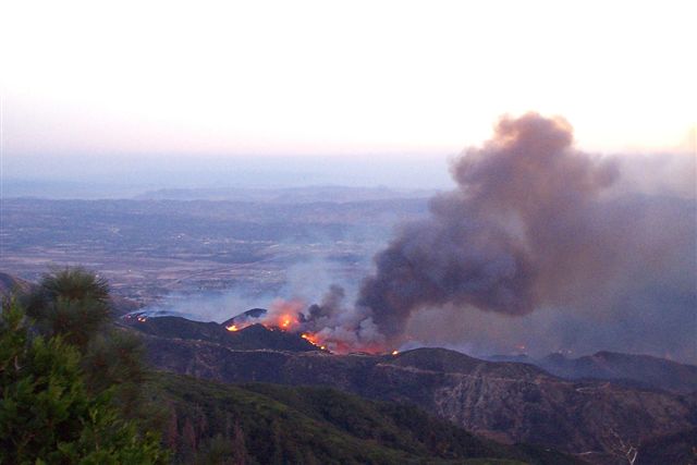
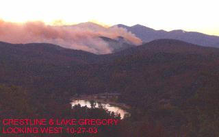
Back firing occurred in the Santa Ana Wash area. Area surrounding Rim of the World High School has calmed. Cedar Glen and Hook Creek--This area of Lake Arrowhead suffered significant losses. The fire is still active in Cedar Glen. Green Valley Lake--Fire is currently burning near this community. Running Springs--the fire is in Plunge Creek Twin Peaks--Structures have been lost near Crestline. 11:00 pm Wednesday- Fire is 10 or so miles from Big Bear. It is still threatening Running Springs and Lake Arrowhead near the hospital. Strong Gusty Winds will make the battle hard. 8:15 pm Wednesday- Fog is rolling into the Crestline area. The dampness should help slow the fires progression. 5:45 pm Wednesday- 350 homes destroyed in the Cedar Glen Area. Mostly around Hook Creek Road, Emerald Lane and Lakeview. Fire heading North East. Winds may blow the flames toward Big Bear 4:15 pm, Wednesday- At least 8 homes burnt in Cedar Pines Park. The water drops helped a lot and limited the fires growth.
3:15 pm, Wednesday- Reports that school in Crestline burned and homes in VOE are burning are false. 2:45 pm, Wednesday- Areas of Cedar Pines Park are burning actively. Structures on Mozumdar Dr. are burning. 2:15 pm, Wednesday- Lake Arrowhead- Fire has burned through Cedar Glen and Little Bear Creek and is wrapping around to the Hospital Area of Lake Arrowhead. Wind is blowing North East. May blow fires down to the Lucerne / Apple Valley area. Crestline- Cedar Pines Park is actively burning. They are still dropping. 1:30 pm, Wednesday- Very active fire drops. Filling from Lake Gregory, a set of 6 helicopters are carrying water straight to the Cedar Pines Park Area! They are dropping about one load per 2 minutes. Battling the fire from the air. The first major flame front tried to jump Highway 330 into the Enchanted Way cul-de-sac in Running Springs at 12:07 p.m. Fire crews on the highway used their hoses to turn most of the flames to steam. But for a few minutes, the fiercely burning flames created the likelihood that glowing embers would trigger spot fires among the homes.
11:45 am, Wednesday- Firemen are backing out of the Cedar Pines Park Area. There are not very many easy escape routes due to the windy roads. They will have to lose structures in the area. Most of the reporters are up in the Lake Arrowhead area so there are no reporters in the area except for Ranger Al. Questions for Ranger Al are now routed through admin@fireupdate.com. Contact us for the latest on the Old Fire Fronts. 11:15 am, Wednesday- Fire is burning near the south east side of Arrowhead near Hook Creek Road. Structures have been lost in the area. I will try post any more info I get. 10:45 am, Wednesday- Ranger Al has traveled and toured the Cedar Pines Park area. The look for the area is grim. Fire is coming quickly up Mozumdar Dr and Sawpit Canyon. There are few Firemen in the area. Homes that are in heavily wooded areas or don't have easy escape routes will probably not be protected. Major loss of homes are expected in the Cedar Pines Park Area. Valley of Enchantment is safe for now. Crestline and Lake Gregory areas are not in any immediate danger.
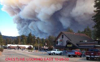
8:30am, Wednesday- The fire is on the North side of Crestline now so the first time Smoke is visible in the Main Crestline area as it is being blown over the hill from the fire burning on the backside of the mountain. The main areas of Crestline are still safe for the time being. The hill between Silverwood and Cedar Pines Park is burning up near the old Mozumdar temple. South end of Hesperia is being evacuated. As the fire tears through the Summit Valley and Lake Silverwood area. Fire has reached Running Strings on the Eastern Front. Still attempting to keep the fire on the South side of Hwy 18.
10:30pm, Tuesday- The Western Part of the Fire has turned North and is heading for the Hesperia Area. Summit Valley, Telephone Canyon & Las Flores areas are in danger.
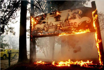
Eastern Part of the Fire has continued to travel. Sky Forest Area has lost some structures Parts of Santa's Village have burned. The NBC News Van has been destroyed leaving reporter Chuck Henry and Camera Man without vehicle. Full Story
12pm, Tuesday- West of Strawberry Peak is burning. Structures in Rim forest are burning. Apache and Blackfoot Trails in Rim forest- 10 homes burned. Charter Cable store is in question. Drop planes are actively dropping all over the mountain. 5am, Tuesday- Firefighters are desperately trying to defend Rim of the World High School.
10pm, Monday- Fire jumps Red Rock Wall and begins to actively burn North of Hwy 18. Fire is still about 1 mile south of Rim high school. Monument Peak area is actively burning while as it heads over the hill and is seen by Hesperia Residents. The fire is actively burning all along Devils Canyon Road but no houses burnt so far as far as we could tell. Fire has jumped into the Pinecrest- Church of Scientology area.
I would like to personally thank Stater Bros. for putting up an additional $50,000 reward for the arsonist. Now its up to $110,000.
|
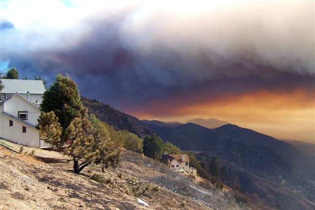
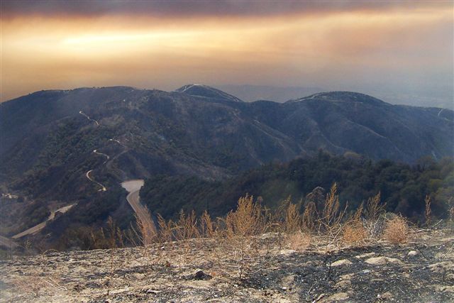
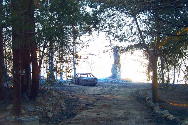
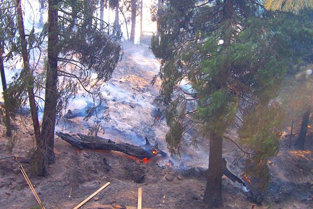
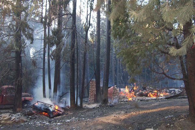
Thank you to John McIntosh for some picture from the area. I've posted some below.
3PM Local
Time Thursday
One more update
at 12:10 PM on Thursday-
8:30AM Local
Time
Ok 11:55 PM
Local Time
6:20 PM News
Update from KNBC Channel 4
4:15PM Wed, Watching three
channels at a time actually switching back and forth and my remote fingers
are getting sprained. Anyway the broadcast from KNBC Channel 4 is a mile or
two west of the Hwy 30 cutoff in Running Springs. They have flames on three
sides of the town (not surrounded so far). Nothing lost yet.
2:45 PM
Local Time
12:30PM Wed, Quick live shot
of Crestline and I could see Lake Gregory in the bottom right of the screen
there is noticeable smoke and fire in the areas that look like Cedar Pines
Park and Valley of Enchantment Wish it wasn¹t
true but it doesn¹t get easier or better-
10:40am, Wed-
The fire is spotting all around the approaches to Big Bear, apparently in
the Arctic Circle area near the summit above Snow Valley. Estimates are only
a few miles from the dam. But there is no defined line of fire- it is
spotting and burning below the tree tops. The TV news shows an arrowhead
house burning. I timed it and it burnt to the ground completely in
less than ten minutes! With the dead trees going very quickly next to the
house. The entire area doesn¹t look good- > Reporter is now showing us the
old Lloyds Restaurant and the town of Running Springs, it looks intact but
for how long? It is starting to get very smoky and it is very strange to see
Hwy 18 in Running Springs with no traffic. The estimate is that fire north
and west of there and the town is still standing with very little structure
damage. It is amazing that the town was saved, for now. Keep your fingers
crossed and stroke the beads-
Learn about the Bark Beetle Click here On October 27, 2003, President Bush declared a major disaster for the State of California, triggering the release of federal funds to help people and communities recover from the Wildfires that occurred October 21, 2003, and continuing. Toll-free Teleregistration number for disaster victims: 1-800-621-FEMA, TTD 1-800-462-7585.
|
||||||||||||||||||||||||||||||||||||||||||||||||||||||||||||||||||||||||||||||||||||||||||||||||||||||||||||||||||||||||||||||||||||||||||||||||||||||||||||||||||||
|
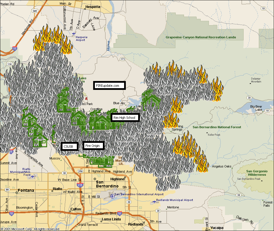
Whole Area of Old Fire
|
|||||||
|
FIREupdate map of the Old Fire Area destruction. (Click on the map for a closer view)
|
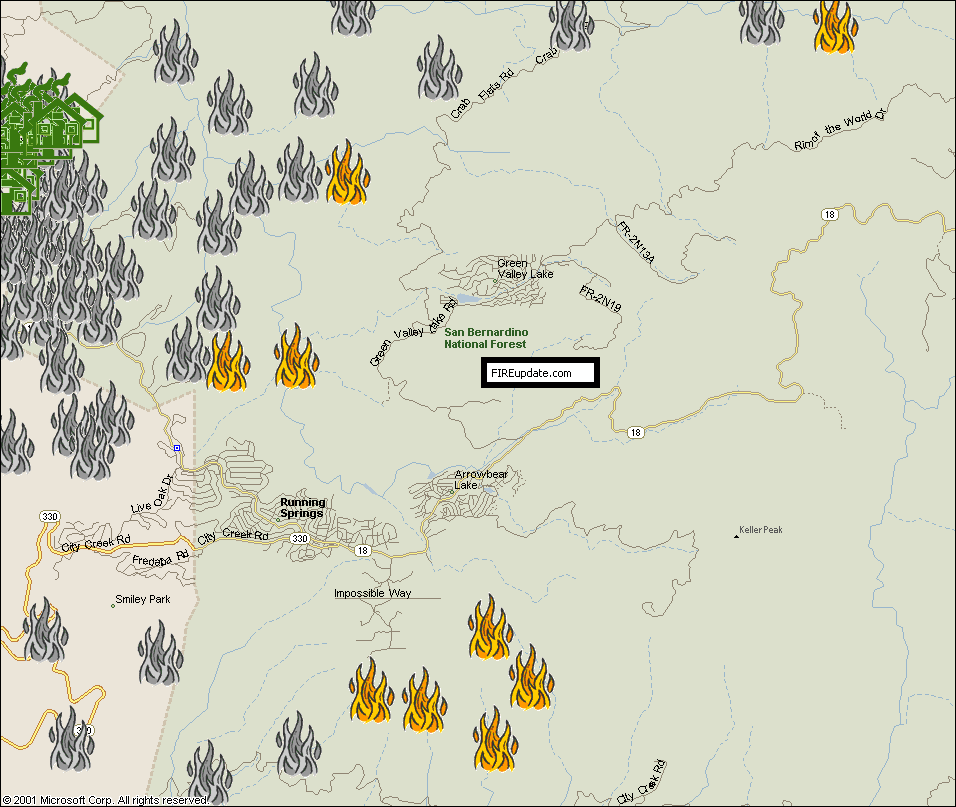
Running Springs Area
FIREupdate map of the Running Springs Area destruction.
|
||||||
|
|
|||||||
|
Crestline Area
FIREupdate map of the Crestline Area destruction.
|
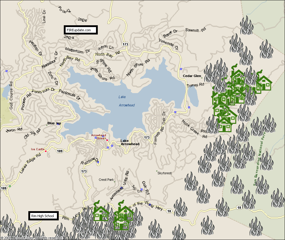
Lake Arrowhead Area
FIREupdate map of the Lake Arrowhead Area destruction.
|
||||||
|
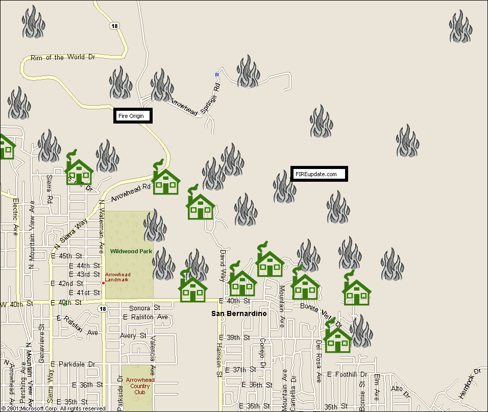
Del Rosa Area
FIREupdate map of the Del Rosa Area destruction.
|
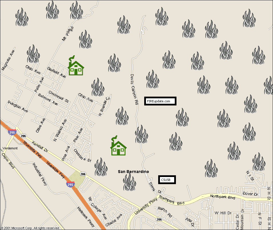
CSUSB Area
FIREupdate map of the CSUSB Area destruction.
|
||||||
Over 90,000 people have been evacuated!
All residents should be off the mountain!
|
Mandatory and immediate evacuation for the communities: |
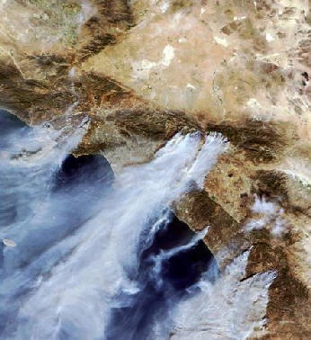 United States Forestry Service Via NASA |
Shelter Information
|
||||
For more information contact: Call (909) 355-8800
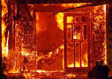 Sandy Huffaker, Getty Images |
Residences Destroyed: more than 520
San Bernardino City- 300 Threatened- 24,000 homes and 500 Commercial Properties
|
1 Firefighter injured with 2nd and 3rd degree burns on legs
4 confirmed deaths
Chad Williams, 70, of Crestline was dashing from his house to his car with his wife on Saturday when he suffered a heart attack.
Gene Knowles, 75, of Big Bear died on Sunday while he was evacuating.
James W. McDermith, 70, collapsed Saturday as he was evacuating his home.
Charles Cunningham, 93, collapsed as he stood in the street watching his house burn Saturday.

![[Graphic]: Map graphic of Old Fire.](images/old_fire_031030_1700.jpg)